Smart city, sacred city: How Varanasi is reimagining crowd flow
Five organisations attempt to solve for Varanasi's crowd-management challenge
Every team scrapped its imported assumptions after working on the ground in Varanasi
From painted walls to AI sensors, they provide five unique lenses on one very unique city

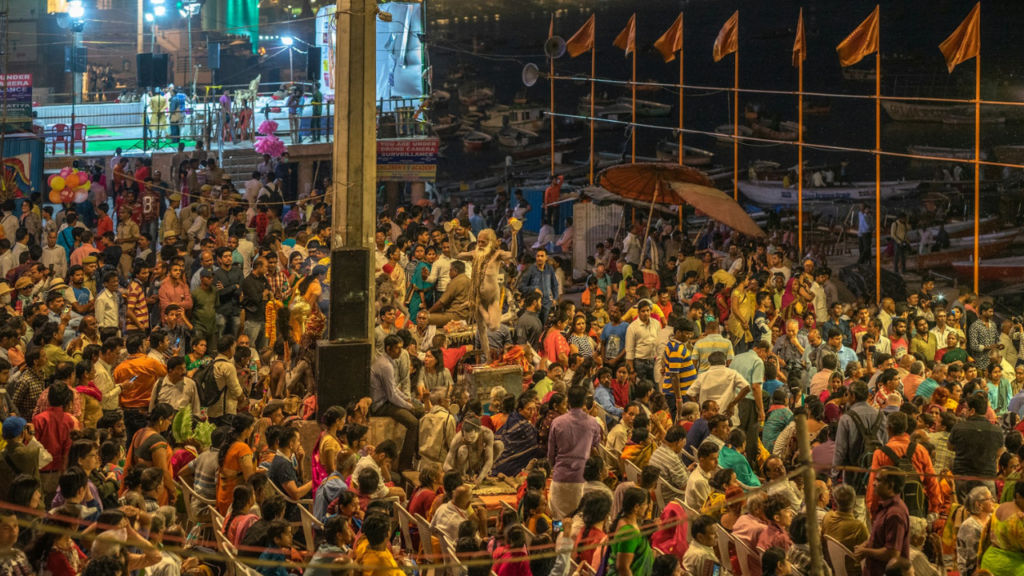
Like endless waves of Ganga flowing by the ghats, so people flock to Varanasi’s spiritual zones with unwavering commitment. In their quest for everything from inner peace and salvation to artistic endeavours and mouthwatering chaat, they don’t stop until their journey’s end, as the ancient city has very well known for thousands of years.
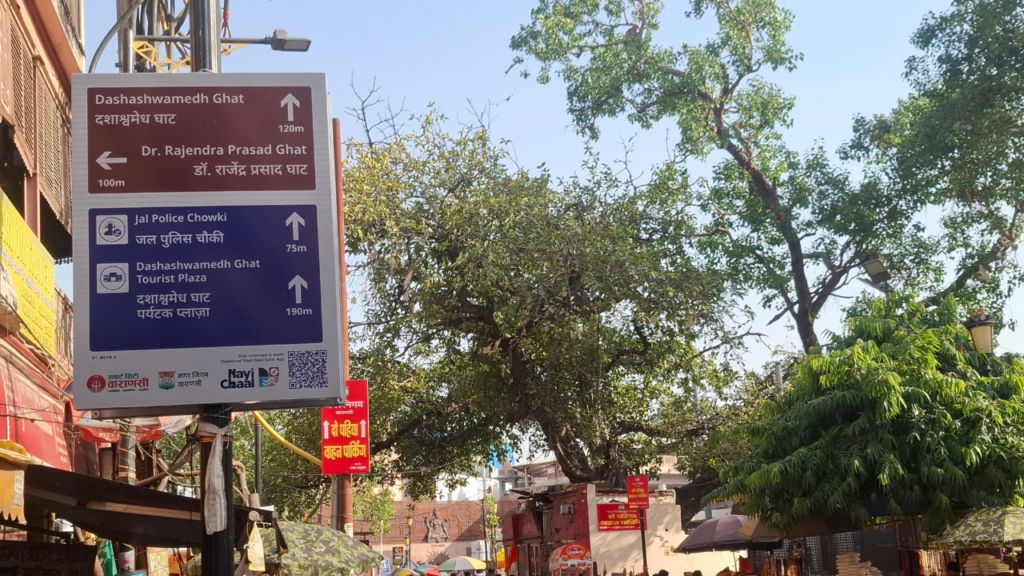
The first time you walk out of Varanasi’s railway station or the airport and into the lanes of the old city that lead toward the ghats, you don’t notice the city by its temples as much as the crowd of people it attracts. Thousands of them pour out of buses, cars, and cycle rickshaws, and start weaving their way through narrow gullies barely wide enough for two side-by-side. They move in waves you can’t fully map. Tour groups and solo travellers share the densely packed roads with cows, scooters, ceremonial processions, sadhus and the occasional SUV. The chaos appears total and unforgiving.
“You see so much chaos when you visit the city for the first time,” said Dipankar Das, part of Arcadis’ team behind a crowd-management ecosystem called Sankalp, when we sat down to talk. “But once you stay for one or two days, you realize in that chaos, there is some sort of rhythm, where things seem to happen on autopilot. And you won’t realise it unless you stay here.”
That observation, in one form or another, has become the starting premise for every startup working in Varanasi, in their quest to present new ideas to help the city become more navigable for anyone visiting its heritage zones in the ancient city of Kashi and beyond.
To that end, in August 2025, the Toyota Mobility Foundation – in collaboration with the City of Varanasi, Challenge Works and the World Resources Institute – named five finalists for its $3 million Sustainable Cities Challenge, focused on transforming crowd management in Kashi.
Each team received $130,000 in early funding to demonstrate their solutions on the ground. I spent a day with all five startups, witnessing how they are trying to make a difference, with their solutions in action on ground. What I realised is that none of them saw what needed to be done the same way. Some saw a measurement gap, where others saw a routing issue. One walked 100 kilometres on foot to make a better map of the old city quarters, while another painted the city’s walls like a primitive geocaching game.
Together they present something far more interesting than any single answer could ever achieve, highlighting a multi-layered argument for what it will actually take to modernize an ancient city like Varanasi.
Sankalp by Arcadis: Giving Varanasi a new situational awareness
Arcadis had prior experience working with places like Tirupati and Vijayawada – similar in terms of religious significance attracting constant crowds of pilgrims. But Das is the first to admit the city of Varanasi humbled them.
“Varanasi has old infrastructure, not everything is updated to a modern or urban city, and that’s part of the city’s appeal,” he said, pointing out the variety of people coming here – from somebody walking barefoot to families in a big car, and everything in between. “This city is able to cope up with all kinds of people,” he said. Their solution, Sankalp, is aimed towards people to make informed decisions. It layers situational awareness on top of the city’s existing playbook – a dense web of walkie-talkies, WhatsApp groups, and the institutional memory of officers who have run Mahashivratri for years.
Also read: BigOHealth: One man’s tragedy to a healthcare mission at India AI Impact Summit 2026
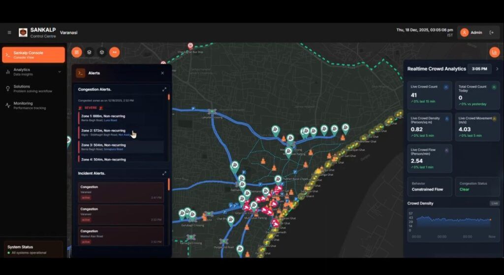
When asked to describe their secret sauce, Das suggested it’s like taking the city’s intuition and accumulated wisdom and backing it with data. “We put the entire thing under a simulation platform,” Das explained.
“If I close a particular road, what is the impact on the other road? If suddenly one part of the road is made a pedestrian only zone, where does it impact in terms of traffic flow? If there is a chaotic situation then how do the people exit?” The point of all this is to convert a previously experience-based decision into “an experience plus data-backed decision” going forward, underscored Das.
During Mahashivratri, the Sankalp team also rolled out Kashi Path – a multilingual web app accessed by QR codes placed along strategic routes, so visitors didn’t have to install anything but still get up-to-date information. In all of this, the deeper learning for Das and his team at Sankalp was how imported assumptions don’t work in Varanasi.
For example, their previous threshold for “dangerous” crowd density, based on temple studies elsewhere, were quietly demolished by local officers in Varanasi. “Everything got challenged there, everything got changed there,” Das said. As a result, the Sankalp team rebuilt its methodology. “That’s the way we see crowds now, it’s much different than how we used to see it before coming to Varanasi.”
CityFlow AI: Measuring the unseen
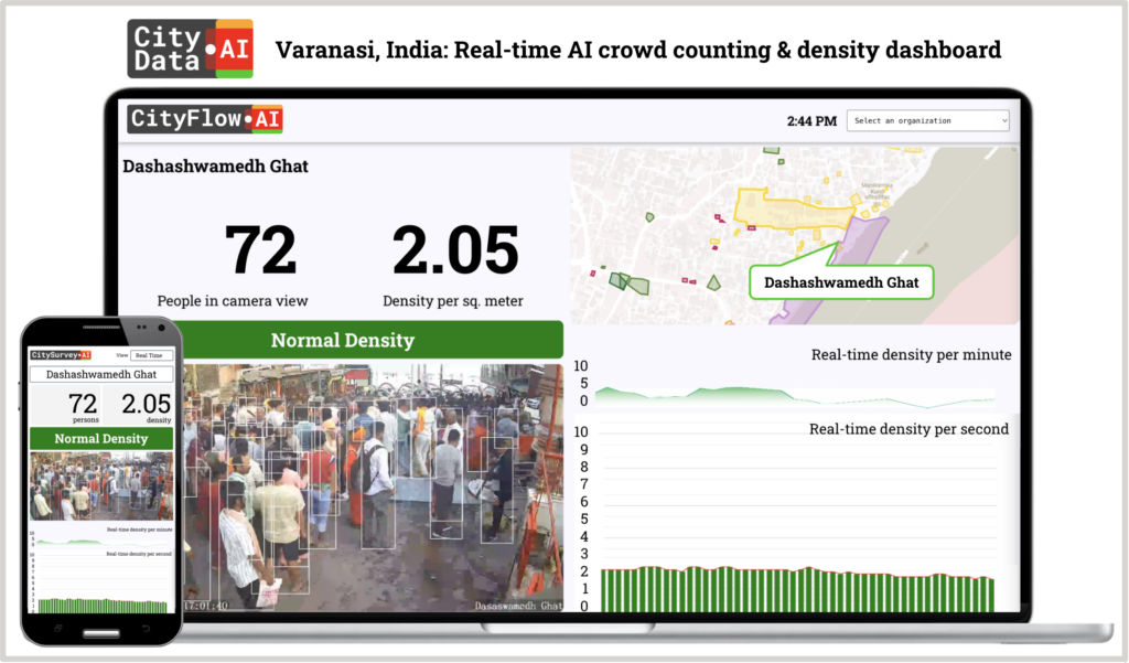
If Arcadis is augmenting the city’s decision-making, then CityFlow AI is feeding it the raw and real-time signal it has never had before. “You can only manage what you measure,” Apurva Kumar, the company’s San Francisco–based founder, framed the problem in a single line. “First, you’ve got to know that there is overcrowding, where and when, and to what extent. And then you can start to apply your interventions.”
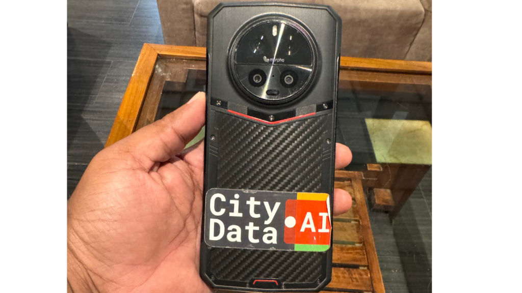
Not for any end user, CityFlow is built for the municipal authority of Varanasi. “We are probably the only innovator that has built a solution exclusively for the municipal authority,” Apurva said, during our chat. The company already has city-scale deployments in the US, Canada, Australia and Mexico. In Varanasi, their input sensor is a military-grade, weatherproof device not much bigger than a modern smartphone, which is mounted twenty to thirty feet above street level.
Computer vision counts the number of humans (with their heads) in their field of view, divided by the walkable area, and publishes a density metric in real-time, explained Apurva Kumar. “Three people per square metre is tight, but you can still walk, you can still breathe. Once it gets to 4-5 people per square metre, you really have no control. You are being carried by the crowd.”
Within a minute of breaching a threshold, CityFlow’s AI system can push alerts to Varanasi Smart City war room and WhatsApp alerts to police and emergency services, along with remedial suggestions based on the city’s existing playbook.
In order to fit the unique Indian context of Varanasi, CityFlow’s AI had to be retrained, explained Apurva Kumar. “Stray dogs, bovine, wheelchairs, auto rickshaws, EV tuktuks,” along with a huge variety of headgear and attire that turns up in Kashi had to be correctly identified to reduce false positives, according to Apurva Kumar. And because cellular networks routinely buckle during mega-events by huge swathes of crowds, every sensor caches a full day’s data locally on 512GB storage, then quietly catches up when the network returns.
Behtar-Way by VOGIC AI: Solving a routing problem
“For people like us who are from North-Eastern UP, we know that Varanasi isn’t just a city. We understand its rhythm,” said Kushagra Rao of VOGIC AI who grew up in Gorakhpur. “When we started working here, we didn’t begin by saying, let’s make a crowd management platform. We first started observing on the ground.” And what they saw reframed the problem entirely. “The main problem isn’t that Varanasi is overcrowded. The main problem is everyone is taking the same obvious route,” Rao revealed.
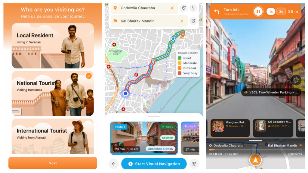
Locals were already using shortcuts “just metres away from the main road.” VOGIC’s product, Behtar-Way, simply tries to surface that local knowledge in an easy-to-use mobile app. Because vehicle-mapped tools like Google Maps can’t enter the inner lanes of the old city of Kashi, the Behtar-Way team built a verified pedestrian network the hard way.
“Rahul Yadav, who heads the operations in Varanasi, and the team walked over 100 km, mapping Panchkoshi, Vishwanath, and surrounding areas like never before.” The intuitiveness of Behtar-Way is that each route gets a walkability score, a video walkthrough so first-timers don’t have to step blindly into a narrow lane, and tagged points of interest – lassi shops, GI-tagged silk weavers, half-forgotten temples. This turns every Behtar-Way recommended detour into a unique exploratory experience of Varanasi.
Behind the app sits Ankush, VOGIC’s proprietary AI layer, with potential inputs from the city’s existing 2,000 IP cameras. Ankush can combine deterministic alerts (for things like parked vehicles, blocked lanes) with a probabilistic model that learns each camera’s normal pattern and sets its own thresholds.
A second patent uses “physical embedding signatures” explained Kushagra Rao, so the system they’re pitching to the city can recognise an ambulance, a wheelchair, or banned vehicles without manually rewriting rules every single time. “See, AI is dumb,” Kushagra said. “It can only tell you that I have found this pattern. Based on that, the call you take, that is where human intelligence comes. So we are not removing humans at all. We are making them super humans.”
NayiChaal by Prameya: Accessibility as the lever
Parshav Sheth and Shail Bajaria, both Mumbai-trained architects, picked the narrowest niche of the five teams and made it the most expansive. “What we are looking at is accessibility,” Parshav said. “If we can provide a last mile kind of mobility solution to someone with the biggest mobility challenges, then automatically that creates a precinct where things are more equitable.”
NayiChaal’s philosophy fuses physical and digital into something Parshav calls “digital urbanism.” Their team segmented Kashi’s heritage precinct into 200 blocks and indexed each one of them on mobility, safety, culture, identity and heritage. They tested their app with people who have partial blindness as well.
“Up until 2020 there was this idea in urbanism where people used to go tactical urbanism, which is popularly known as jugaad in India. While we realised that Varanasi is very fertile for tactical urbanism, you still need IoT.”
Their dashboard, Niyantran, runs an urban simulator that lets city officials drag-and-drop interventions – a wheelchair pick-up point here, a canopy there, a signage in between – and see the impact on a parametric score.
“This is complete gamification of their problem,” Parshav said. The team also runs climate sensors at each Ghat (PM2.5 at Manikarnika is “just off the chart”) and digital signboards that can re-route in real time when, say, VVIP movement shuts down a lane.
They are also operating in a city changing under their feet. Post-2020, Varanasi has seen “a 45x times increase in the number of people,” and the demographics are shifting, as younger visitors are arriving with very different expectations, according to Shail. But the team is careful not to overreach. “The police officer standing there takes the final call,” Parshav said. “How do we empower that guy? How do we tell him that in the next 30 minutes, this action will lead to that reaction?”
The biggest insight came at Mahashivratri 2026, when every digital tool failed: “If everything fails, Prameya has digital signboards with real-time rerouting capacity,” underscored Parshav.
JanJatra by The Urbanizer: Painting the city’s wayfinding
Siddhi Soni and Vanshika Shah are urban designers, not technologists, and their solution shows it. They observed that Varanasi already had crowd management, but “it was not interconnected. It was operating on an individual level,” Soni pointed out.
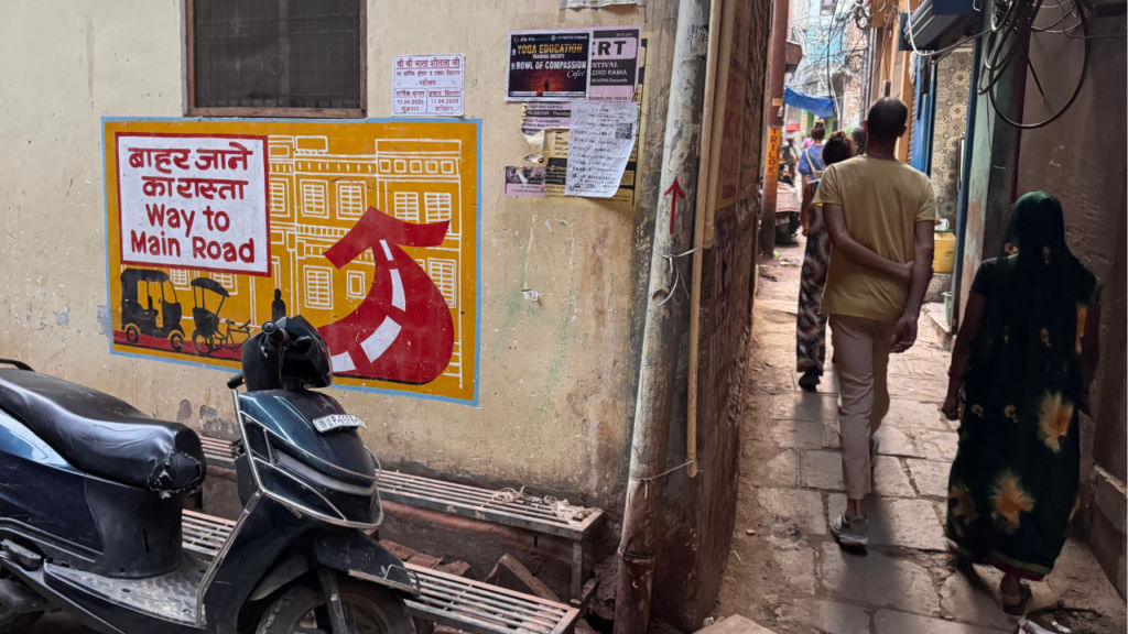
Their resulting fix is a colour-coded pedestrian signalling system that’s painted onto the streets themselves – blue for the way to a ghat, yellow for the way to a temple, red for the way back to the main road. Delightfully simple. “Ours is a network-based implementation,” Siddhi said. Think of it as a metro line, except the lines run along the floor of the lanes and the riders walk.
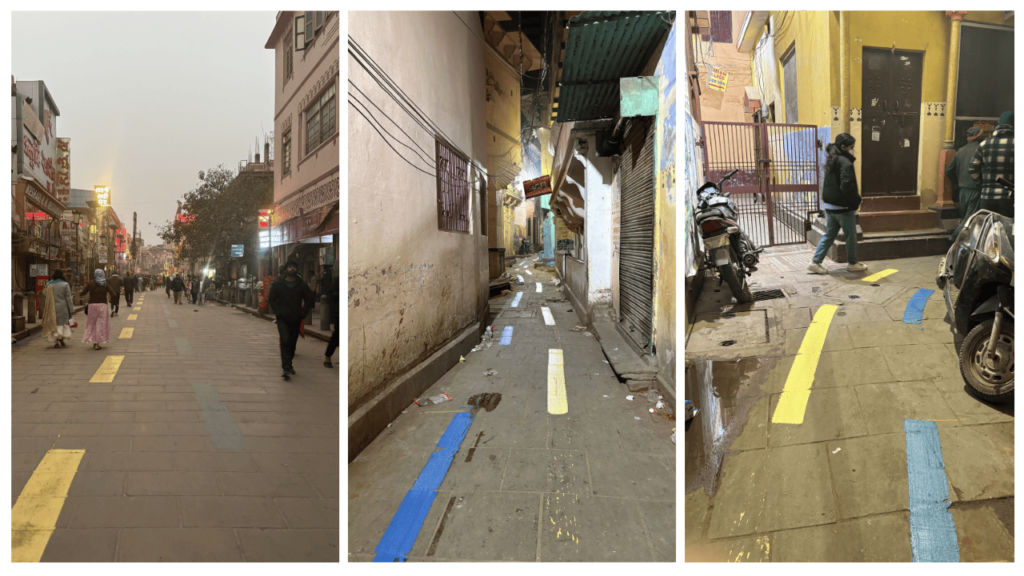
Their solution’s colour logic is rooted in a demographic insight that other tech-led teams might have missed. “Not all people may know how to read or write, you just need to know what colour represents what action, and you just need to follow that colour.” When the floor disappears under a deluge of feet – a regular Mahashivratri occurrence in Varanasi – vertical signage on walls still provide colour-coded routing information. The Urbanizer’s art is matched to the existing visual grammar of the lanes, painted in collaboration with Nagar Nigam under Swachh Sarvekshan guidelines. “We do not want to put something alien into this context,” Vanshika said. “We want to make use of the existing things that are already there.”
On top of the murals, the team has installed CCTV-based AI density detection wired to dynamic digital signboards. It can override everything else and steer pedestrians left or right depending on real-time crowding – with authorities holding the final override switch, according to Siddhi and Vanshika.
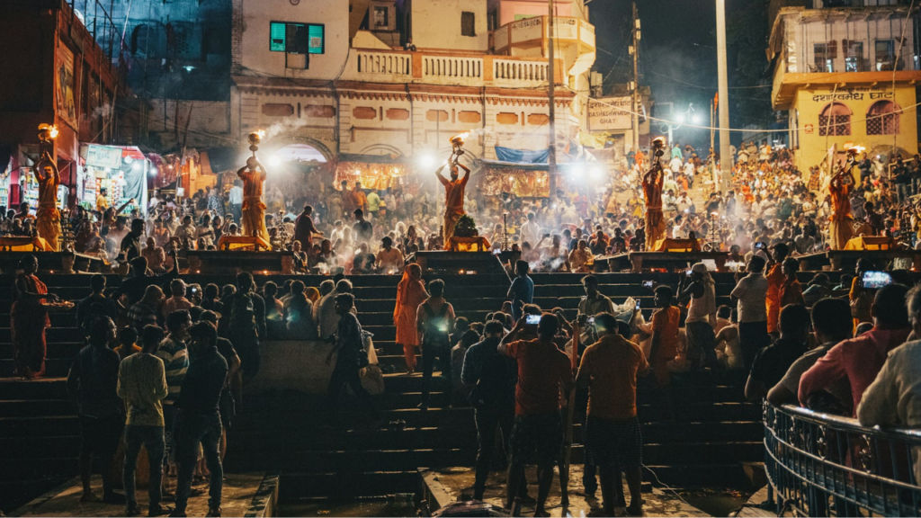
Perhaps their most touching win is how it works with evening Ganga aarti organisers at Dashashwamedh Ghat, where they painted zones in blue to indicate where the crowd should and should not sit. “Daily, in aarti, they announce that you sit inside the blue line. Or you sit outside the blue line. That’s a huge success for us,” Siddhi Soni said proudly.
Their closing word for the rest of the field is unflashy but correct all the same, “Crowd management is such an on-ground thing, you can’t always depend upon the tech. You can depend on tech for an overview, but it has to be bottom-up,” highlighted Vanshika Shah quite rightly.
Five lenses, one city
What ties these five solutions together is not technology. It is humility – a shared recognition that Varanasi will not be arm-twisted into doing anything in a hurry, it needs patient listening for solutions to surface.
Every team came in with a model and ended up rebuilding it on the ground. Arcadis raised its crowd-density thresholds because local officers genuinely manage volumes that elsewhere would trigger panic. CityFlow retrained its computer vision because Indian streets contain Indian things. VOGIC walked 100 kilometres because a car-mapped world cannot find the city’s shortcuts. NayiChaal was built for the wheelchair user first because it knew the gain would compound. The Urbanizer painted walls because half the visitors cannot read the signs.
That bigger question – whether what works in Kashi can be replicated elsewhere – isn’t lost on the Challenge’s architects either. “The ancient city of Varanasi is where spirituality and history converge in deeply profound and human ways. We believe the innovations demonstrated by the five finalists in Varanasi can serve as a blueprint for other religious and heritage cities, while also improving the quality of life for their residents,” said Pras Ganesh, Executive Program Director at the Toyota Mobility Foundation.
The city itself is leaning into the experiment, as you start to witness yourself after spending a few days walking through Varanasi’s gullies and Kashi’s ghats – especially along the ancient city’s heritage corridor, where these disparate attempts to solve on-the-ground problems start to feel real and cohesive. The ultimate hope is to see if the city that taught five organisations to question their own assumptions can also show rest of India what participatory urban development can look like.
Also read: Building skyscrapers in India just became a lot faster with AI, says Inkers Technology