Scientists mapped 2.75 billion buildings in 3D, and you can find your home in this interactive map
Scientists map 2.75 billion buildings in 3D globally
Interactive 3D world map lets you find your home
AI built the first complete 3D map of Earth

For most of human history, maps have flattened the world. Cities appeared as outlines, buildings as blocks of colour, and entire neighbourhoods were reduced to symbols on paper or screens. That limitation is now being challenged by a new scientific project that has mapped an estimated 2.75 billion buildings across the planet in three dimensions. The result is an interactive global map where users can zoom in almost anywhere on Earth and often locate their own home.
Known as the GlobalBuildingAtlas, the project represents one of the most ambitious attempts yet to visualise humanity’s built environment. Instead of showing where buildings sit on land, it shows how they rise from it. Dense city centres suddenly appear as forests of vertical structures, while smaller towns and rural areas reveal their low rise, spread out character. The map turns abstract urban statistics into something instantly visible.
Also read: ChatGPT app marketplace explained: How it works, what developers gain
How scientists mapped billions of buildings in 3D
Creating a 3D model for every building on Earth would be impossible using traditional surveying methods. To solve this, researchers relied heavily on artificial intelligence and satellite imagery. Machine learning models were trained on hundreds of thousands of high resolution satellite images to recognise building footprints and estimate their height.
The system analyses visual cues such as shadows, surrounding terrain, and spatial context to predict how tall a structure is likely to be. These predictions are combined with global elevation data to generate simple 3D building forms. While the models do not capture fine architectural details, they accurately represent a building’s footprint, height, and overall volume.
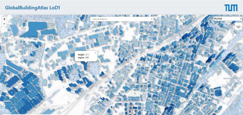
Scientists describe this as a Level of Detail 1 representation. It is basic but consistent, which is crucial when working at a planetary scale. Around 97 percent of the world’s buildings are included, making it the most comprehensive global building dataset ever created. Importantly, the data is designed to be open and accessible, allowing researchers and planners to use it without relying on proprietary systems.
Why this map matters beyond curiosity
Also read: OnePlus 15 vs iQOO 15 vs Realme GT 8 Pro battery drain test: 6 hours, 3 flagships, 1 winner
The ability to find your own home on the map gives the project instant appeal, but its real value lies in what it enables. A 3D view of buildings allows for far more accurate analysis of how people live. Two neighbourhoods with similar land area can look completely different when building height is taken into account, revealing differences in population density, housing availability, and infrastructure pressure.
Urban planners can use the data to better understand how cities grow vertically or horizontally. Climate researchers can estimate energy demand and heat retention more accurately by analysing building volume instead of surface area alone. In disaster prone regions, the map can help assess risks by showing where tall, dense housing is concentrated compared to low rise settlements.
The dataset also exposes global inequality in a new way. Some regions build upwards due to limited land and high population pressure, while others sprawl outward. These patterns reflect economic conditions, planning policies, and access to resources. Researchers have even proposed new measures, such as building volume per capita, to compare living conditions across countries.
More than anything, the GlobalBuildingAtlas establishes a new baseline for understanding humanity’s footprint on Earth. As cities expand and climate challenges intensify, knowing how the world is built will be as important as knowing how many people live in it. For the first time, the planet’s buildings can be seen not just on a map, but in three dimensions, with your own home as part of the story.
Also read: Memory crisis: Dell, Lenovo to limit some laptops to 8GB DDR5 RAM in 2026