NISAR Earth Observation Satellite Facts
In a significant leap for space-based Earth observation, the NASA-ISRO Synthetic Aperture Radar (NISAR) satellite is set to launch on July 30, 2025 at 5:40 PM IST from the Satish Dhawan Space Centre in Sriharikota. According to ISRO, this joint Indo-US mission will be one of the most advanced remote sensing systems ever put into orbit and it could become a game-changer for how we monitor the Earth’s surface in real time.
Here’s a deep dive into the five key features that make NISAR an unprecedented global mission in Earth observation.
Also read: 5 crazy facts about Chile’s Vera Rubin telescope: It has world’s largest digital camera
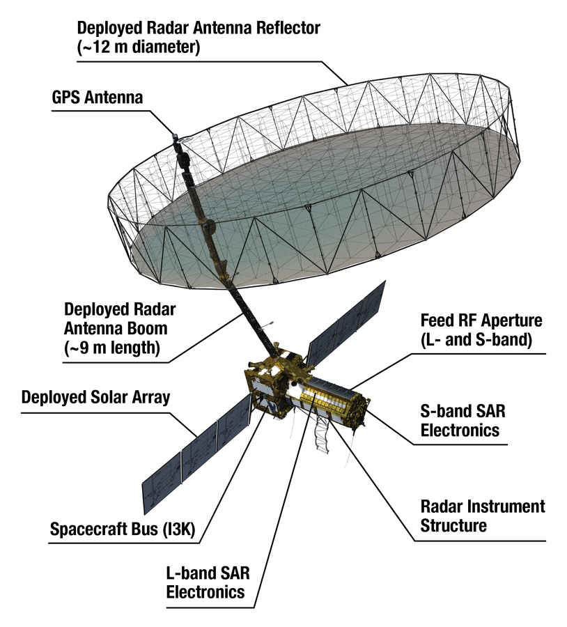
At the heart of NISAR lies its dual-frequency Synthetic Aperture Radar (SAR) – a first in space history. Developed through a collaboration between NASA’s Jet Propulsion Laboratory and ISRO, the satellite carries both L-band (1.25GHz) and S-band (3.2GHz) radar systems. These operate together using a 12-meter-wide mesh reflector antenna which is roughly the size of a tennis court.
The combination of the two bands allows NISAR to detect minute deformations and movements on the Earth’s surface, regardless of cloud cover, day or night. This makes it ideal for observing everything from glacial shifts and tectonic activity to forest biomass and agricultural patterns with exceptional detail and consistency.
NISAR’s radar system isn’t just about sensitivity, it also brings an unmatched blend of swath width and spatial resolution. The satellite can scan an area 242 kilometers wide in a single pass, while maintaining a resolution range of 3 to 100 meters, depending on the observation mode.
This is made possible through an advanced radar technique called SweepSAR, which balances wide-area scanning with high-resolution imaging. Such capability is crucial when it comes to keeping a close eye on fast-changing phenomena like cyclones, landslides, or crop failures, where detail and coverage are equally important.
A key strength of NISAR lies in its revisit frequency. Orbiting the Earth at an altitude of 747 kilometers in a sun-synchronous orbit, the satellite will complete a full scan of the planet every 12 days. This consistent revisit cycle is essential for time-sensitive applications, such as tracking how glaciers move, how forests grow or shrink, how agricultural fields develop over seasons, or how coastlines erode. The sun-synchronous orbit ensures that imaging happens under similar lighting conditions each time, which improves the reliability of comparisons over time. Additionally, overlapping swaths and data calibration between passes mean that some areas could be observed even more frequently. In disaster-prone zones or ecologically fragile regions, this kind of monitoring can offer early warnings, prompt damage assessments, and long-term trend analysis, all with a dependable rhythm.
Also read: Interstellar Visitor Spotted by Astronomers: What Is It?
A key strength of NISAR lies in its revisit frequency. Orbiting the Earth at an altitude of 747 kilometers in a sun-synchronous orbit, the satellite will complete a full scan of the planet every 12 days. This consistent revisit cycle is essential for time-sensitive applications, such as tracking how glaciers move, how forests grow or shrink, how agricultural fields develop over seasons, or how coastlines erode. The sun-synchronous orbit ensures that imaging happens under similar lighting conditions each time, which improves the reliability of comparisons over time. Additionally, overlapping swaths and data calibration between passes mean that some areas could be observed even more frequently. In disaster-prone zones or ecologically fragile regions, this kind of monitoring can offer early warnings, prompt damage assessments, and long-term trend analysis, all with a dependable rhythm.
One of the most progressive aspects of NISAR is not just what it observes, but how its data will be shared. This mission is built on an extraordinary collaboration between two of the world’s most prominent space agencies – NASA and ISRO – both of which have pooled their expertise, technologies, and vision to create a shared scientific platform. Even more notably, NISAR will operate under a fully open data policy, making its satellite imagery and analysis tools freely available to scientists, disaster-response teams, environmentalists, and governments around the world. Most data will be released within 24 to 48 hours of collection, and in some cases, emergency data could be delivered in near real-time. This democratic access to high-quality Earth observation data ensures that even developing countries or small organizations can benefit from the insights NISAR provides.
Set to launch on July 30, 2025, at 5:40 PM IST aboard ISRO’s GSLV-F16 from the Satish Dhawan Space Centre in Sriharikota, NISAR will enter a 747-kilometre sun-synchronous orbit with a 98.4° inclination. Its arrival marks a turning point in how humanity observes its own planet, offering unprecedented resolution, frequent global revisit rates, and free, near-real-time data access. Combining cutting-edge engineering with humanitarian objectives, NISAR stands poised to revolutionize Earth observation, enabling breakthroughs in disaster response, climate science, and environmental stewardship. As the countdown begins, global anticipation builds not just for the launch, but for the scientific and societal transformation it promises to ignite.
Also read: NASA unveils full-scale prototype telescope that aims to detect gravitational waves